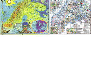
Triggered by European Union’s Raw Material Initiative and intensified resource mapping, a negotiation of the limits of exploitation is emerging; in it decision makers go to extremes in accepting environmental damage. This paper unfolds discourses on resource extraction from two cartographies representing the same territory with different names and worldviews. The artist-cartographer Hans Ragnar Mathisens counter mapping, and the geological maps from the Fennoscandian Ore Deposit Database. Landscape changes on all scales calls for an in-depth cooperation and exchange in order to draw material links from the disappearance of the smallest biotopes, to the larger suppression of local agencies to control their own destinies. These landscapes, homelands, pastures and bases for local sustenance, are under pressure. Recognition of reindeer herders landscape knowledge might be a key to resist the bit-by-bit depletion of northern landscapes. May postcolonial reading be of help in investigating how to change stakeholder relations, and how it is possible to act on, relate to and understand the on going, but not yet materialized changes in the North?Can such a discourse offer a space for negotiating and exploring the tools of planning and governance with regards to environment and mineral wealth and how to enter a conversation about corporate claims, indigenous self-determination, and collective action?